Backward Seasons and Remarkable Cold:
the Weather over Long Reach, New Brunswick, 1812-1821
Liza PiperYork University
1 ON 10 APRIL 1815 THE TAMBORA VOLCANO on the island of Sumbawa in the Indonesian archipelago erupted with violence unprecedented in historic time. The eruption had been brewing for several years. Ominous clouds gathered at the peak of the Tambora crater in 1812 and slowly travelled down its flanks. By early April 1815, rumblings and minor explosions came from inside the volcano, growing in intensity and frequency over the following few days. When volcanic activity peaked on 10 April, it killed an estimated 92,000 people on the islands of Sumbawa and Lombok, either from the direct effects of the eruption or the ensuing famine, epidemics and social disorder. A column of volcanic ash and gases extended 43 kilometres into the sky and the total erupted mass was an order of magnitude greater than the material discharged by Krakatau (Krakatoa) in 1883 and two orders of magnitude greater than the Mount St. Helens eruption in 1980.1 Explosions and earthquakes reverberated over 1,000 kilometres away, the sea level rose suddenly by four meters and ash fell from the sky for seven days.2
2 The Tambora eruption was locally catastrophic, but its impact extended far beyond the Indonesian archipelago. The volcanic matter that spewed out of the crater in April 1815 was propelled into the atmosphere and, by means of normal atmospheric circulation, spread across the globe. The role of volcanic eruptions in affecting far-distant climates is well documented in the historical and scientific literatures.3 In the centuries before humans induced climate change with the concentrated production of greenhouse gases, the main factors that forced climatic changes were solar variations, volcanic eruptions and changes in the ocean-atmosphere system.4 The Tambora volcano, when it erupted in 1815, ejected a remarkable amount of gas and particulate matter (including water vapour, sulphur compounds, carbon dioxide and ash) into the atmosphere.5 By scattering and absorbing solar radiation, these aerosols effectively caused the air closer to the earth’s surface to cool.6 An explosive eruption on the scale of Tambora carried more aerosols, including larger particles, higher up in the atmosphere than the better-known eruptions at Krakatau and Mount St Helens.7 The "dust veil" that was formed by these aerosols effectively reduced the transparency of the atmosphere, although initially this impact was felt only at the site of the eruption. Because of the low latitude of the Tambora eruption, it took a relatively long time for the dust veil to travel, by means of high-level atmospheric circulation, away from the equator north and southwards until it ultimately dissipated over the poles.8
3 Volcanoes play an important role in reconstructing historical climates, as they are unpredictable or chaotic factors that can severely disrupt natural climate variability or the otherwise broadly rhythmic seasonal patterns in any given place.9 Historians J.D. Post, William Baron and Timothy Ball, among others, have explored the impact of the Tambora eruption on the climate of North America and Western Europe.10 In northeast North America and particularly in New England, 1816 was memorialised as "eighteen-hundred-and-froze-to-death" or "the year without a summer" as frosts and freezing temperatures disrupted the summer months.11 The impact of Tambora in British North America is less well known than in either Europe or the United States. Histories of the early-19th century make repeated reference to crop failures, high prices and a difficult season in 1816. Yet these studies neither detail the extreme weather that year and its local impacts nor have they explicitly linked the harshness of the season to global climatic anomalies.12 This is an omission that this paper seeks to partly redress through an examination of the impact of Tambora in southern New Brunswick. The impact of volcanic eruptions on local climates can vary considerably and, more importantly, their social and economic effects are conditioned by the level of development in each given community.13 Historians have most commonly studied the impact of the Tambora volcano on food supply, a key determinant in the social stability of early-19th-century societies. J.D. Post and Brian Fagan suggest that in Western Europe the extreme weather that resulted from the eruption produced "social unrest, pillaging, rioting, and criminal violence" in 1816 and 1817. In New England, farmers and their families went hungry and prices for food and commodities skyrocketed; however, social unrest on the scale of Europe did not occur.14
4 Different challenges faced the less-developed British North American colonies. Created in 1784 with the migration of Loyalist refugees from the American Revolution, the colony of New Brunswick, except for the fewer than 10,000 people in pre-existing Native, Acadian and other European communities, was still only 30 years old. In significant ways, agriculture was in its pioneer phase; farming competed for the attention of settlers with the emerging trade in square timber, which was stimulated after 1800 by the negative impact of the Napoleonic Wars on the timber supply in Great Britain.15 The rapidly growing integration of forest production into many, if not most, farming operations in the colony provided a hedge against crop failure. Indeed, alternative means of subsistence were necessary, as the progress of agricultural development was compromised not only by the effects of the Tambora volcano but also by a series of poor growing seasons. The entire second decade of the 19th century was characterized by harsh and highly variable weather. Building on the historical research from Europe and northeast North America, 1816 can be understood as a "natural disaster" with considerable immediate impact on individuals and communities. However, by situating the weather of 1816 within a long-term anomaly, questions also arise as to the effect of prolonged harsh weather on the competing place of agriculture and the timber trade in the young colony.
5 This paper focuses on environmental conditions and economic history: it examines how the extreme weather in the decade of the 1810s, climaxing in the 1816 "year without a summer", likely had a lasting impact on the overall relationship between farming and forest production. It focuses on the diary of Benjamin Crawford, a farmer in the lower Saint John River Valley who kept a detailed daily record of weather conditions from 1810 until his death in 1859.16 A close analysis of the diary, particularly between 1812 and 1821, reveals the importance of weather conditions as a factor in the rational calculations of farmers. The strains of hunger and economic insecurity brought on by the extreme and unstable weather in this period had both immediate- and longer-term consequences for the Crawford family farm. The experience of the Crawfords and their neighbours, in turn, suggests ways that this decade of hard weather, coming as it did during the earliest development of colonial economy and society, placed constraints on agricultural activity and discouraged farming families from ever wholly abandoning forest production.
Diaries and Historical Climatology
6 The type of information available for the reconstruction of past weather and climate is crucial to the degree of detail that can be achieved.17 Instrumental records, descriptive documentary evidence, archaeological data and natural proxy evidence all provide different variables and data for the reconstruction of past climates. Instrumental records, with varying degrees of precision, date only from the late-19th century in New Brunswick. These records can be used to compare climatic conditions in the early decades of the 19th century with later periods. In New England, temperature records were kept at various colleges before and after 1816.18 The longest continuous instrumental record, begun in 1779, comes from Yale College in New Haven. The geographical proximity of this older set of records from Connecticut can give a general indication of the weather, or at least its larger parameters, in New Brunswick.19 It is possible to gain some insight into the climate history of southern New Brunswick from within this larger climatic setting. However, local climate regimes are determined by such distinctive features as local topography, bodies of water and forest cover. Therefore, to effectively reconstruct the historical climate of southern New Brunswick, a more local record is essential.
7 Instrumental records provide actual measurements of the weather and are relatively rare. More readily available historical and natural evidence is found in the form of proxies. Proxies are derived from weather- or climate-dependent occurrences in animal and plant life and the physical surroundings, and include much of the information found in the seasonal or annual layers of tree rings, ice cores and lake sediments.20 A tree ring, for example, does not record the atmospheric temperature in which it was formed; its width, however, indicates the relative length of the growing season. Such types of sources can provide continuous records of past climates, but are generally limited in resolution to changes over months, seasons or even longer periods. Similarly, the use of archaeological data, such as evidence of extinction and desertion of settlements, are useful for examining longer-term climate variations.21
8 One of the richest forms of information on past climates are what Le Roy Ladurie originally termed documentary evidence – sources that include direct information about both the weather and phenomena and events dependent on the weather.22 Farmers’ diaries – a form of descriptive documentary evidence – are acknowledged as important and unique sources for climate history. William Baron, for example, supplemented 18th-century instrumental records with farmers’ diaries to construct a paleotemperature sequence for New England beginning in 1600.23 As compared to travellers’ accounts and letters, also common sources of weather observations, farmers’ diaries are important for their regularity and because they are fixed in place.
9 Benjamin Crawford’s diary is a pre-industrial daybook that includes running accounts of receipts and expenditures combined with notes on important family events, occasional personal reflections and comments on work begun or completed.24 As historian Kathryn Carter noted, "diaries of this [account-book] type have often been overlooked by scholars because they seem inexpressive and opaque".25 Economic and climate historians have used these sources to develop time series, creating data sets in which each record is corroborated by the evidence of the others.26 Crawford’s diary is limited because it is only one source and the observations recorded – both social and meteorological – are distorted through Benjamin Crawford’s eyes. Nonetheless, in this one source there is an account of nature (or natural phenomena), an account of early-19th-century farming and an account of Crawford’s personal life. Reading these three accounts together and interpreting the diary as both a data set and a text reveals the interrelationship of an individual with his natural environment.
10 Benjamin Crawford’s diaries include both meteorological variables and proxies.27 To determine the state of the atmosphere, meteorologists measure precipitation, temperature, air pressure, humidity, cloudiness and wind speed and direction.28 Temperature, precipitation, wind speed and wind direction are the most consistent sources of weather information in Crawford’s diary. He described temperature using such adjectives as: "cold", "warm", "very hot", "cool" or sometimes, less precisely, "good weather" or "fine". The diary noted precipitation as simply "rain", "snow", "hail" or "dry" and also commented on snow squalls and flurries. Crawford described how long precipitation had lasted, whether it "raind last night" or was "still snowing". On occasion he even measured the depth of snow in the woods, but not regularly enough to create a consistent record. Wind speed was "strong", "hard", "blusterin" or "still", with the direction given and duly noted when it shifted. Crawford also commented when it was cloudy and when it stormed.
11 To use Crawford’s diary as a measure of past weather requires further interpretation; after all, a "cold" day in June 1814 has no direct degree equivalent in the 21st century. Present-day meteorology is more precise but relies in many respects on the same information that Crawford recorded. Crawford measured precipitation not in the amount of rain or snow that fell but the number of days when there was rain or snow. Crawford’s diary is consistent with, albeit less sensitive than, present instrumental records of precipitation, which can register as little as a tenth of a millimetre of rain or snow.29 Prevailing wind direction, storminess and cloudiness are likewise readily accessible by examining Crawford’s monthly records and are comparable to present-day meteorological data. Temperature is the most problematic variable; when considered as a relative value rather than as an absolute, however, Crawford’s record is revealing.30
12 European climate historian Christian Pfister emphasizes that "many [pre-industrial] observers were well aware that their individual feelings of cold and warm were subjective. In order to demonstrate the anomalous character of a season, they often referred to observed signs in the physical or biological world".31 Crawford was no exception, and his observations of the physical and biological world reveal the broad ecological repercussions of the weather anomaly of 1816-17 and provide valuable proxy information including blossoming dates and the timing of the river freeze-ups.32 Proxies are also more interesting, in some respects, than simple descriptions of the weather outside, as they signify ways in which the weather interfered with human activities. Crawford’s interest in recording the breakup of the Saint John River lay in its significance to local transportation as much as its place as a natural phenomenon worthy of record.
13 In addition to the meteorological and proxy data available in documentary evidence, there is also anecdotal and other descriptive evidence. Anecdotes are valuable for setting particular weather events within the context of the observer’s experience. Crawford noted, for example, that on 4 June 1812 Long Reach experienced "the most severe storm that was ever [known] in June By the oldest inhabitant". Such descriptions offer the historian a sense of the perceived intensity of a given weather event. However, they are limited to the observer’s context and, when used in isolation, the description of a particular storm or sunny day is rarely precise enough to provide evidence of the cause of a given event. The combination of quantitative and descriptive information on the weather available in Benjamin Crawford’s diaries provide the foundation for reconstructing the weather at Long Reach after 1812.
Physical Setting
14 The local expressions of large-scale weather anomalies can vary considerably and it is therefore essential to understand the local setting of a weather event. The community of Long Reach lies on the northwest side of the Kingston Peninsula, inland from the mouth of the Saint John River, which drains into the Bay of Fundy (see Figure One). Two bodies of water form a U-shape around the Kingston Peninsula, which is oriented northeast-southwest: Kennebecasis Bay constitutes the southern arm of the U, while Long Reach parallels Kennebecasis Bay on the north side of the peninsula. Bellisle Bay forms a northeastern extension of the Reach, and here the River takes a sharp turn to the northwest towards Gagetown and Fredericton.
Figure One : Map of the Mid and Lower Saint John River
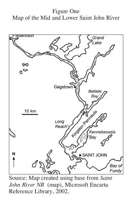
Display large image of Figure 1
15 The waters of the Reach present several obstacles to easy navigation (see Figure Two). Oak Point, the site of St. Paul’s Church where the Crawfords attended Anglican services, is the most pronounced promontory on the northern side of Long Reach. Just above Oak Point the waters of the Reach become marshy and shallow; the marshland surfaces above the water for most of the year at Grassy Island, where local farmers harvested summer hay and the suitably named Mistake Intervale hooks around Mistake Cove. Directly to the west of the community of Long Reach is Caton’s Island, an important reference for Crawford’s annual descriptions of the river ice.
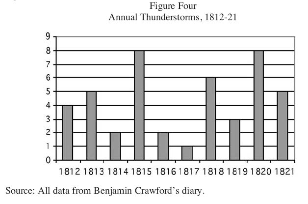
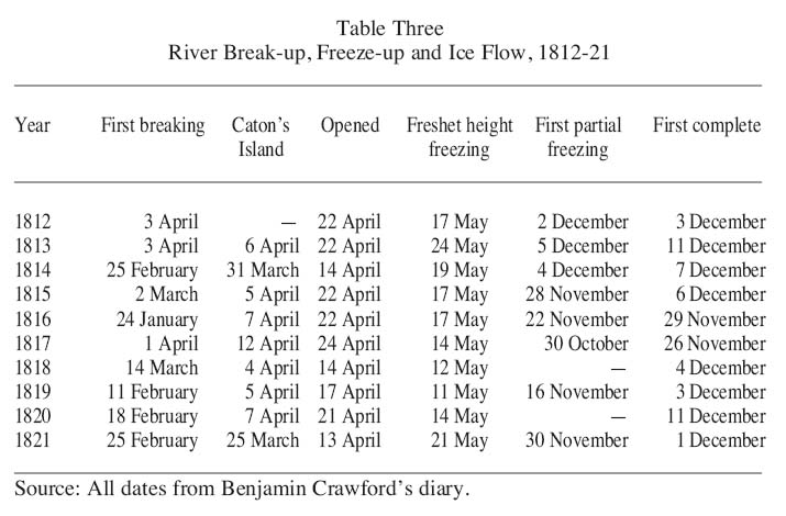
Figure Two : Detail of Long Reach
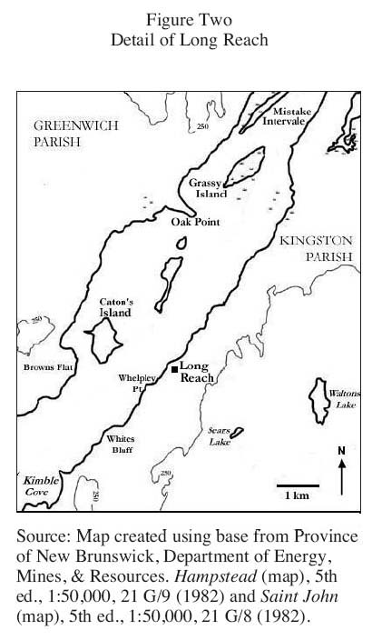
Display large image of Figure 2
16 Long Reach is surrounded by high ground, sloping gradually in the upper part of the Reach and sharply enough to the south to form bluffs and cliffs. The high ground provides the paths along which water drains into the finely textured valley soils, supplying moisture for the cultivation of crops. The shores of the lower Saint John River include the most fertile farmland in New Brunswick. The length of the lower Saint John River Valley was covered by the most deciduous of the six forest zones in the colony.33 Although Crawford did not bother to name the trees he cut as he cleared his land, the forests at Long Reach consisted mainly of hemlock, red spruce and white pine.
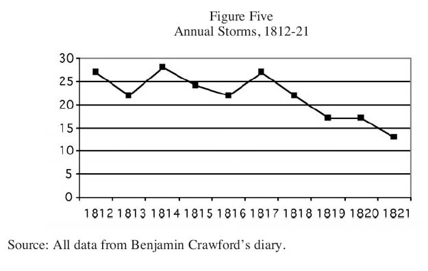
17 The Maritime Provinces, situated at the easternmost edge of a continental landmass, are greatly influenced by weather patterns travelling westwards across North America. Their proximity to the ocean also has important regional consequences.34 Salt water and sea fog often travel as far up the Reach as Oak Point, and the air temperature along the Reach reflects the mixing of continental air masses with the temperature-moderating effect of the ocean.35 Along the Fundy shore, to the south of Long Reach, the frost-free period is the longest in the province at 140 to 160 days on average. By comparison, the frost-free season in the upper Saint John River Valley is only 108 days.36 Nevertheless, the climate of Long Reach is far from idyllic. The winter is especially erratic as temperatures fluctuate and storms bring strong winds accompanied by a mixture of rain and snow. The summers can be warm, but are frequently punctuated by cool, wet weather. The rolling hills surrounding Long Reach affect the local climate as the uplift from the high ground makes Long Reach susceptible to summer thunderstorms.37
18 The lower lands on the north side of Long Reach, from Caton’s Island to Oak Point, exposed the Crawford farm and environs to the full strength of northwesterlies. Winds from the west and northwest predominated in the cold months and could hit gale force. In summer, the waters of the Reach become "choppy seas" when the typically south and southwest winds oppose the strong, southward flowing current between Oak Point and Caton’s Island. Although the Crawford farm was blessed with fertile, well-drained lands, it was also exposed to harsh and unpredictable winds, storms and waters.38
19 Implicit in this description is a degree of continuity between present-day southern New Brunswick and the physical setting of the region at the beginning of the 19th century. Many of the important landscape features that affected the local climate remain, regardless of the phenomenal changes wrought by the urban and industrial transformation of the past 200 years. However, a more important change has taken place in the climatic regime itself. There is a general consensus that the climatic conditions linked to the glacial advance known as the Little Ice Age came to an end around the middle of the 19th century.39 The close of the Little Ice Age stopped the "endless zigzag of climatic shifts" that had characterized European climate beginning as early as 1300.40 Although there were significant regional variations in the severity of the Little Ice Age, the temperate northeast coast of North America experienced conditions similar to that of Western Europe.41 Reaching its cold trough in the late-17th century, a period of greater stability and prolonged warming followed the constant flux of the Little Ice Age circa 1850, a trend that continues to define the global climate.42 The "year without a summer", though, took place during the Little Ice Age, and while the abrupt shift in the weather in 1816 was similar to the erratic weather of the Little Ice Age in general, it not only had a different origin but also characteristically different effects.
Backward Seasons, 1816-17
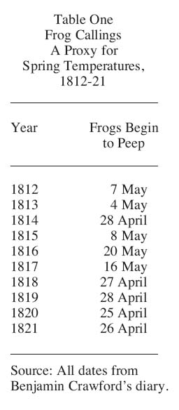
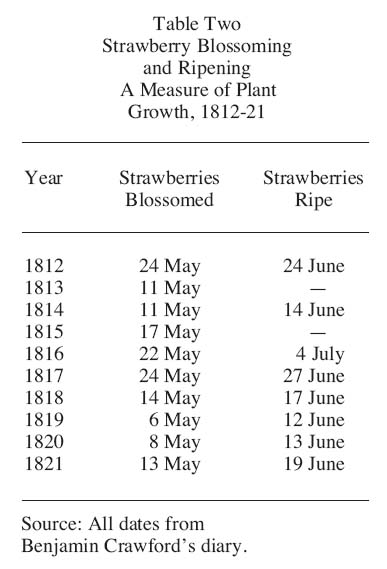
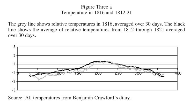
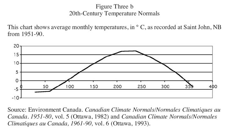
20 Benjamin Crawford’s repeated characterizations of the spring weather as "backward" provide the earliest evidence that something was amiss in 1816. Although he did not draw attention to it, that year the frogs took longer than ever to start "to peepe". Spring peepers need temperatures around 20 ºC before they will begin their search for a mate. The callings recorded every year in Crawford’s diary are thus an excellent measure of when the spring turned to summer (see Table One). In 1816 the frogs did not start calling until the 20th of May, substantially later than any other year except 1817. From the plant blossoming and ripening dates in Table Two, it is clear that this cold weather delayed plant growth. The cold, however, did not depart with the spring. In June of that year Crawford saw snow on the mountains behind his farm. The absence of references to summer thunderstorms, otherwise common in July and August along the Reach, further indicated cooler summer temperatures. By comparing the temperature in 1816 to the average of the decade examined, it is clear that in the spring and summer the temperature was both more irregular and consistently colder (see Figure Three a and Figure Three b).
Table One : Frog Callings A Proxy for Spring Temperatures, 1812-21
Display large image of Table 1
Table Two : Strawberry Blossoming and Ripening A Measure of Plant Growth, 1812-21
Display large image of Table 2
Display large image of Figure 3
Display large image of Figure 4
21 The colder temperatures did not pass unnoticed in the larger community, and articles in the New Brunswick Royal Gazette attempted to explain the cold weather. In 1816 the Gazette featured three separate pieces that suggested links between the cold temperatures and increased visible sunspot activity. The first appeared in May and drew attention to "a spot of considerable magnitude . . . on the disk of the sun". In July an article reprinted from the Berkshire Star ended with the following passage: "It is often asked if the extraordinary coldness of the season be not caused by these spots? . . . From the observations which have been made, it has been concluded the seasons were warmer and more fruitful, in which the sun was the more covered with spots".43 Although it is impossible to know whether the link was made at that time, a separate report of volcanic ash falling over the Indian Ocean published in the Gazette in June 1816 pointed more accurately to the source of the problem. Theories about the relationship between sunspots, sunspot cycles and weather anomalies persisted into the 20th century, and fluctuations in solar radiation remain an important variable in understanding short- and longer-term weather anomalies.44
22 Although some volcanic ash fell over the Indian Ocean, much was propelled into the stratosphere and from there spread north and south toward the poles. It was en route north when the Tambora dust veil travelled over Long Reach in the early months of 1816 and brought with it the anomalous cold weather recorded by Crawford and his contemporaries. The complexity of weather dynamics are such that the colder temperatures produced by the Tambora dust veil in turn had further repercussions on the local climate. The cooler temperatures chased away the thunderstorms that in most years prevailed during the months of July and August (see Figure Four). The fall and winter of 1816-17 was nevertheless especially cold and stormy, and brought more rain and snow to the Crawford farm than in any other year of the decade. By the spring of 1817 the severity of the winter months led Crawford to remark in his diary that this was "the hardest season that we have ever had for many years".45 More directly, the accumulated snowfall and cold temperatures kept the Saint John River frozen longer – the ice was the thickest it had been in thirty years – and the spring freshet "was as high as was ever known".46
Figure Four : Annual Thunderstorms, 1812-21
Display large image of Figure 5
23 The persistent cold of 1816 triggered the increased precipitation and storminess: it weakened atmospheric circulation by reducing the difference in air temperature (and hence air pressure), thus keeping the polar front from retreating north at its normal pace.47 This amplified the characteristic concentration of low pressure centres over the St. Lawrence Valley that, in a typical summer, subject the eastern provinces of Canada to the prevailing influence of winds from the south, southwest or west.48 Lower summer temperatures in central and northern Canada consequently kept the storm track further to the south, suspended over Long Reach. Baron similarly concluded that the summer of 1816 in the northeastern United States was especially stormy.49 Thus, the remarkable cold of 1816-17, directly linked to the 1815 Tambora eruption, was itself the cause of stormy weather in this same period.
The Longer Setting, 1812-21
24 Communities across British North America not only felt the cold of 1816-17, but also experienced a longer period of harsh weather beginning as early as 1811. In his study of central Canada, Timothy Ball noted that "between 1800 and 1810 the climate was relatively benign, holding promise of better conditions and times in the 19th century. The promise was short-lived as temperatures began to decline in 1811, a trend that was to continue through to 1818".50 A.J.W. Catchpole studied river freeze-up and break-up dates recorded in the annual logs of the Hudson’s Bay Company. He similarly concluded from this data "that in the second decade of the nineteenth century cold summer weather was not initiated after the eruption of Tambora in April 1815, but was first apparent in 1811 and 1812".51 From this analysis it is clear that erratic weather was common in the years preceding 1816.
25 The years 1812 and 1814, along with 1817, were the stormiest of the decade, while the years from 1819 through 1821 were below average for the period examined (see Figure Five). Although Long Reach’s geography made it particularly susceptible to stormy weather, during these years the storm frequency was not only greater but storms were also especially fierce. On 4 June 1812, for example, Crawford noted that "this day there was a provecy that the world [would] be at an end – the most severe storm that was ever [known] in June By the oldest inhabitant". Just over two years later, on 24 June 1814, Crawford remarked that "this storm is the Coldist that Ever we have had in this place at this season it blew so hard and cold that it distroyd most of the Cucumbers and brok down the Corn".52
Figure Five : Annual Storms, 1812-21
Display large image of Figure 6
Table Three : River Break-up, Freeze-up and Ice Flow, 1812-21
Display large image of Table 3
26 As in 1816-17, prolonged cold characterized the stormy springs of 1812 and 1813, evidenced by the relatively late break-up of ice along the Saint John River (see Table Three). But in 1814, the other stormy year, the spring was relatively warm, and on one occasion in April Crawford was surprised by "a Remarkable warm day for the season the Cattle [sweat]. Remarkable uncommon". There were also wet anomalies in 1813 and especially 1818, which had more days with precipitation than any other year. The wet weather brought infestations of grubs and plenty of horseflies to the Crawford farm in both years.53 Although there was erratic and harsh weather in the years between 1812 and 1816, there is no clear pattern as compared to the cold and stormy seasons of 1816 and 1817.
27 Consistently warm weather returned to the Reach only after 1817, and after 1818 the precipitation likewise diminished. The frogs were now calling in late April, not late May and there were fewer days with rain and snow. In 1820 and 1821 the temperature was less erratic and the river opened early in 1821, as in 1814, pointing to the warm spring weather. The dry summer heat beginning in 1819 brought thunderstorms and, on one notable occasion in July 1820, it "came on to thunder and Rin with hail of an Extrordinary size of a musket baul".54 Drought was the other unwelcome result of the hot summer of 1820.
28 The Tambora volcanic dust veil presents a straightforward explanation for the cold and stormy weather in 1816 and 1817. For the harsh seasons that lasted from 1812 to 1819, however, the possibilities are more complicated. There is evidence that other volcanic eruptions in the period from 1809 to 1814 may have contributed to producing an even larger dust veil than that created by Tambora alone.55 These other eruptions were nowhere near as explosive as Tambora, thus it is unlikely that their impact was commensurate with that of Tambora. There is also evidence to suggest that this weather may have originated in the North Atlantic Oscillation (NAO). The NAO is an undulation in atmospheric pressure between the Azores high and the Icelandic low. It governs the position and strength of the North Atlantic storm track and thus the rain that falls on Europe and North America, especially in winter.56 The NAO index is the measure of the shifts in the oscillation, and a high or positive NAO index will bring signature weather to a region. In New Brunswick the positive phase is characterized by stronger westerlies, a more intense storm track and warm and wet anomalies. A locked positive phase of the NAO could have produced the storminess, precipitation and fluctuating temperatures apparent in Long Reach prior to 1816.57 Greater certainty about the role of the NAO in disturbing the atmosphere over Long Reach requires additional evidence from southern New Brunswick and elsewhere in northeast North America. A more general interpretation of the origins of the erratic weather reconsiders the larger climatic context of the Little Ice Age, which has been subdivided into a stormy "zonal" onset, a calm "meridional" maximum and a stormy "zonal" end. Increased storminess thus characterized this end period, which included the early-19th century; the Little Ice Age, evidently, went out with a bang.58
Crop Failures, Migration and the Timber Trade
29 Crawford’s diaries, in combination with other evidence and contemporary meteorological science, detail the character and origins of the backward seasons and remarkable cold that climaxed in 1816-17 over Long Reach. This reconstruction reveals that harsh and erratic weather became relatively commonplace over southern New Brunswick in this early period of the colony’s history. The harshness of the seasons after 1812 called for a response from the predominantly agrarian society of southern New Brunswick. Communities did not just endure the effects of distant and seemingly random natural forces – they responded to them. The shape of this response reflected the strain under which communities suffered and the resources and opportunities they had at their disposal to deal with these challenges. How did this weather impact on individuals and communities? To what extent were the responses of New Brunswickers to the weather exceptional and to what extent did they mirror their counterparts in communities around the globe?
30 Historians of the 1816 "year without a summer" emphasize the global extent of the harsh weather felt in northeast North America, Europe, East Asia and beyond. North American and European experiences are loosely grouped together as the response of the Western world to the subsistence crisis. Even within this broader grouping, however, there were obvious differences between Western Europe, British North America and the American states. Post acknowledges that while Western Europe faced famine, disease and violence, "Canada", by contrast, "passed through the threatening dearth without serious social problems – an outcome not unexpected in a land with such a favourable population-resource ratio".59 Yet the evidence available in Crawford’s diary and newspaper articles indicates that the impact and significance of erratic weather, particularly in 1816-17, was not so straightforward.60
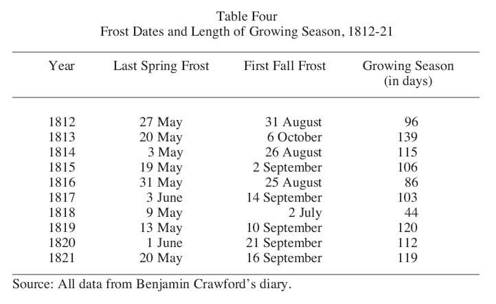
31 William Baron emphasized that in New England the cold of 1816 shortened the growing season dramatically and corn crops especially "were an almost total failure".61 He argued that it was the crop failures, rather than just the cold temperatures that produced them, that were the source of 1816’s notoriety. The length of the growing season is measured by the number of days from the last frost to first frost. Crawford kept a record of the last spring frost and first fall frost in each year (see Table Four). From this evidence it is clear that 1816 was not the only year with a remarkably short growing season. Baron noted that, in some years, early frosts (and therefore abnormally short seasons) might be attributed to "one-night radiational cooling under clear skies during either spring or autumn, and not to prolonged outbreaks of cold weather".62 With a frost recorded on 2 July, such an occurrence was likely in 1818, as there is no corroborating evidence of a cold summer that year. Otherwise, 1812 and 1816 recorded the shortest growing seasons and 1817 is distinguished by the latest spring frost – on 3 June that year. The blossoming dates recorded in Table Two reiterate this pattern and further demonstrate how the inclement weather beginning in 1812 affected plant growth.
Table Four : Frost Dates and Length of Growing Season, 1812-21
Display large image of Table 4
32 While 1812 and, to a lesser extent, 1813 and 1815 may be deemed hard years, in 1816 and 1817 the weather was severe enough to bring about crop failure and scarcity. In September 1816 Crawford noted that "scarcely any corn or beens got ripe this season".63 Corn, especially, was a temperature-sensitive crop that had suffered in the unseasonably cold summer months.64 Grain prices (oats, wheat and corn) all peaked in 1817, a reflection of the scarcity in the previous year. Likewise, hay production along the Reach suffered in 1816 such that by April 1817, with livestock still dependent upon the fodder produced in 1816, Crawford noted that it was "a destressing time for the want of hay severel all most out".65 Even without this direct statement, the increased transactions between Crawford and his neighbours over hay and the rumoured high prices that Crawford noted in his diary throughout March and April (as much as £12 per ton), demonstrated that this commodity was in great demand.66
33 As in New England and much of Western Europe, the year without a summer brought crop failure and scarcity to New Brunswick. The further effects of this scarcity, however, were not nearly as dire in New Brunswick as elsewhere. In Western Europe the crops that failed fed substantial urban markets by means of well-established transportation networks. The faltering grain production in the countryside brought famine to agricultural labourers and urban populations who, even if they participated in its production, still purchased their food. The extent of famine varied considerably across Europe. Post argues that France and the Netherlands experienced a severe dearth of food, while famine was widespread in southwest Germany, Ireland and the lands of the Hapsburg monarchy.67 Although the American states did not suffer famine, the failure of the corn crop, the staple of the local diet, in combination with scarcity in other crops, brought food shortages and fears of starvation to the interior towns and settlements of northern New England.68
34 There is no evidence to suggest that New Brunswickers faced famine, although their crops did fail and food scarcity and hardship ensued. The early Loyalist settlers, including Crawford and many of his neighbours, benefited the most from large grants of prime agricultural land along the Saint John River. In the decade under review, Crawford slaughtered up to 6 pigs, 15 sheep and 9 cattle a year. To maintain his livestock, he produced up to 25 tons of hay and 30 bushels of oats each year. Annual grain production ranged from 17 to 35 bushels of buckwheat and 10 to 20 bushels of wheat. The Crawfords were prosperous with plenty of good, fertile land and a productive farm that produced a surplus for market. That they and their neighbours did not starve or obviously suffer from serious food shortages only reveals what one segment of colonial society faced during the dearth of 1816-17. An 1816 report from Charlotte County, west of Long Reach, stated: "Crops of hay and potatoes are very slim, Cattle are very cheap, Men is plenty and Money was never known to be so scarce".69 Agricultural labourers, poorer farmers and workers in Saint John likely experienced considerable hardship in these years. It is important to note, nevertheless, that the Gazette in this period wrote of hardship, not famine.
35 The population of New Brunswick grew in this period, from 25,000 in 1800 to 74,176 in 1824, and the majority of this population were farmers.70 Saint John was an expanding urban centre and an important market for agricultural produce that travelled down the Saint John River from the communities along its shores and beyond. In the decade under examination, Benjamin Crawford and his neighbours regularly brought their farm products to market. Alan Taylor has suggested that the dearth following harsh weather across New England in 1789 (also linked to a distant volcanic eruption) "discouraged people with grain from parting with it, hindering the movement of food".71 This may also have been the case in New Brunswick; there is no evidence to quantify how much grain was on the market in 1816 as compared to 1812 or 1819. But the evidence from Crawford’s diary reveals that food and specifically grain was still available, albeit at much higher prices.
36 Crawford kept a record of his own and some of his neighbours’ trips to Saint John and generally recorded the prices of goods bought and sold in the market. In this period Crawford recorded an average of 28 trips to town each year by himself and his closest neighbours and family. In 1815, 1816 and 1817 these numbers spiked to 35, 34 and 35 trips respectively. Crawford himself went to market in town nine times in both 1816 and 1817, up from his usual seven trips in other years. These years were also the first and only time between 1812 and 1821 that Crawford purchased flour on the market, pointing to his own farm’s inability to provide this staple. The only other year in which Crawford’s trips to town peaked was 1820, the year that saw drought along Long Reach. If others in Long Reach and beyond followed the pattern of Crawford and his neighbours, then the demand for food and grain in Saint John peaked during the hardship of 1816-17 and again in 1820. Prices of foods rose dramatically in response to this demand and the scarce supply. Crawford had meat and grain to sell, thus he could afford to buy flour for his family. It is likely that many others in New Brunswick could not.
37 Fear and suffering were not the only possible responses to food scarcity and hardship. A longer-term response to prolonged cold weather was the adaptation of crops and livestock to the new, harsher weather conditions. The crop hardest hit by the cold was hay, which was central to the Crawford farm economy because it was necessary to fodder livestock through the winter months.72 After 1816 the Crawfords lessened their dependence on hay by shifting their focus from cows to sheep. Sheep are primarily fed oats and consume only small amounts of hay.73 Stommel and Stommel observed a similar shift in New England, where "1816 was a year of heightened interest in sheep raising". They also maintained that sheep survived harsh winters in better condition than cattle.74 Accordingly, where butter was previously central to the money-making enterprises of the Crawfords, its importance declined after 1818. In 1818 the Crawfords’ butter sales peaked at 583 lbs; by 1822 the Crawfords sold 211 lbs and in 1826 only 58 lbs were sold. Within this same period the number of sheep maintained by the Crawfords almost doubled, from 23 sheep and lambs to 43. This adaptation emphasizes that the decade-long experience of hard weather brought about long-term consequences. Shifts in farm production were not undertaken lightly and after 1817 they represented a response to a perceived shift in environmental conditions.75
38 Another longer-term consequence of the harsh seasons was migration. In Western Europe and northeastern North America, 1816 and the years immediately following were marked by a spike in migration as people fled hunger and the fear of starvation for what they hoped were better lands – a migration spike exacerbated by the end of the Napoleonic Wars and the release of military men. Post argued that, in the United States, cold weather and crop failures in 1816-17, in addition to overpopulation and soil exhaustion, encouraged migration from the eastern states in the 1810s.76
39 Migration was clearly an issue in New Brunswick, as indicated by an article in the Gazette which reassured farmers in New Brunswick about the inclement weather of 1816. The author pointed out that "the two preceding years have been unfavourable to the pursuits of agriculture" and that potential emigrants "should first consider that this is not the only country that is liable to bad seasons the eastern States have felt them as well as this Province, and Canada, which is a fine grain country, has for a few years back suffered much from bad seasons".77 The harshness of the years leading up to 1816 caused contemporary observers to worry about the impact of the vicissitudes of the weather upon the regional economy. As the bad weather persisted, local farmers either stayed and suffered or packed up and left in the hopes of better harvests elsewhere. Migration also brought new settlers to New Brunswick. In 1818, for the first time, Crawford hired a man, "John Natter the Irishman", to help with the hay harvest in exchange for two pigs. Between 1816 and 1818 Irish emigration to the United States and Canada rose from 6,500 to 20,000. John Natter was one of thousands of Irish immigrants to British North America who found passage on returning timber ships and one of the factors that possibly pushed him and his compatriots into the holds of these vessels was the food scarcity and famine in Ireland that resulted from the year without a summer.78
40 For those who stayed in Long Reach, social relations were otherwise strained as the cold weather and crop failures that year corresponded to allegations of witchcraft. On 6 August 1816 Crawford noted in his diary that "Poll Kimble is said to be Bewichd she lives [with] William Kimble at the point". Within two weeks Crawford had recorded that "Old Baly at B[ill] Kimbles to kill the wiches".79 The historian Wolfgang Behringer has argued that witchcraft persecution in Europe was sometimes closely related to "unnatural" weather that destroyed harvests.80 He concluded, "the age of the great persecutions corresponded generally to the ‘Little Ice Age’ and the individual hunts corresponded to specifically catastrophic years".81 In her exploration of New England witchcraft beliefs and persecution, Carol Karlsen similarly noted that storms, fire and crop damage were attributed to malefic witchcraft.82 The presumed presence of witches in Long Reach revealed that community members perceived supernatural forces at work in the harsh weather that destroyed their crops. The close relationship between the supernatural and the weather was also evident in 1812, when Crawford noted "this day there was a provecy that the world [would] be at an end – the most severe storm that was ever [known] in June".83
41 Across North America and Europe, agrarian communities susceptible to the ravages of an individual storm or a season of cold temperatures often perceived erratic weather as a deeply malevolent force. This weather also tells us much about other aspects of these communities. If we take Crawford’s record of the witch and her demise at face value, this single incident, when compared to the violent social responses to the subsistence crisis overseas, evokes the profound distance between these different societies. In 1816-17, Western Europe witnessed looting, rioting and arson and, more importantly, grain riots and even taxation populaire – the imposition of popular price control by collective action. Popular disturbances and resistance in Europe by principally urban workers and the majority of the rural population threatened by hunger represented collective action against bankers, farmers and grain merchants who controlled credit and the food supply. The much greater social complexity and the attendant collective divides in the European cities and countryside clearly brought fundamentally different social responses to the hunger of 1816 as compared to the responses evident in the small, relatively close-knit farming community of Long Reach, New Brunswick.
42 Agriculture was the principal economic activity in New Brunswick well into the late-19th century, and it was also the activity most affected by the Tambora dust veil and the extraordinary weather from 1812 to 1818. Yet early agriculture in New Brunswick was a productive and expanding enterprise situated in the midst of pervasive forests.84 Occupational pluralism – the division of labour between farm and forest – characterized 19th-century New Brunswick economy and society, and Graeme Wynn, Béatrice Craig and others make it clear that lumbering coexisted with farming in supporting farm families and working men. The value of the timber trade fluctuated over time, but it grew steadily from 1805 to 1825. This peak in the timber trade was principally a result of British policy that supported colonial timber during Napoleon’s Baltic blockade as well as effective resistance against efforts to reduce tariff preferences to the colonies in the immediate post-war years. The colonial preference, persistent British demand for timber and the constant arrival of potential new forest workers on the returning trans-Atlantic timber ships converged to stimulate lumbering in New Brunswick on a scale not previously seen.85
43 This period of growth in the timber trade also largely coincided with the decade under examination in this paper and this coincidence demands closer examination. In spite of the growth and significance of agriculture to the New Brunswick economy, marginal soils and an unreliable climate posed considerable challenges to families who sought to maintain flourishing farms. Crawford and his neighbours worked to ensure the continued fertility of their soils by manuring and liming as well as planting beans and peas.86 As detailed above, in the decade from 1812 to 1821, farmers faced more intense challenges when "backward seasons" and "remarkable cold" brought crop failures and scarcity to farm families even along the fertile intervale lands of the Saint John River. The environmental and, more specifically, climatic context of this period of relatively early agricultural settlement in the colony suggests that the potential for hardship among families too dependent on farming was an important factor in their decisions about if and when to divide their time between farm and forest.
44 That they did divide their time thus is evident from the participation of many men in the timber trade in winter while clearing their land and claiming grain bounties for the summers between 1817 and 1825.87 Crawford himself remained primarily interested in his farm, but several of his neighbours, including Sam Holder, the Williams brothers and David Bulyea, all became increasingly preoccupied with forest work after 1816. In 1819 and 1820 three sawmills were erected along the Reach; these were the first sawmills mentioned in Crawford’s diary.88 After 1817 the government required licenses for cutting trees on Crown land, although this new legislation was only partly observed.89 This same year, Crawford and his neighbours had their lands surveyed in order to clearly demarcate the extent of their wooded lands. The people of Long Reach were evidently relaxed about the extent of their property prior to 1817: when Henry Whelpley and James Williams had their "line run" in April 1818 it turned out that "Mr Williams cut two winters cord wood on Mr Whelpleys lot beside tun timber".90 The hardship attendant on farming likely pushed many of these men to look to the woods. Moreover, the same weather that caused the harvests to suffer was by contrast well-suited to the timber economy. Long, cold winters lengthened the season for felling trees and kept snow on the ground easing the transportation of wood.91
45 The rise of the timber industry brought far-reaching changes to communities in southern New Brunswick. After 1816 there was a noticeable decline in the number of frolics in Long Reach – occasions when the community members pooled their labour, skills and equipment. The last wood frolic noted by Crawford was in May 1820, where previously there had been several frolics a year; farming and quilting frolics declined more gradually. The Irishman Crawford hired in 1818 was one of thousands of newcomers who created a pool of waged labourers for hire as farm help, whereas previously, community endeavours had supplemented individual efforts. Catharine Wilson’s article on reciprocal work bees in 19th-century Ontario (what Crawford called frolics) emphasised that the decline of bees corresponded to the rise of a cash economy. Instead of sharing labour through frequent frolics and bees, the growing availability and importance of cash and the expansion of the labour pool, both corollaries to the expanding timber trade, provided alternate means for farmers to get the help they needed.92
46 The decline of frolics also highlights the kind of impact the inclement weather of the 1810s had on the community at Long Reach. Frolics, or bees, were an opportunity to share labour, skills and equipment; during this decade, however, and especially in 1816, the problem was not a shortage of labour but a shortage of crops.93 Thus the rise of waged and gang labour accompanied the decline of cooperative community endeavours as the need to maximise production exceeded the combined social and economic functions of frolics. This transition must be understood as a response to the hardship of the period as well as the new opportunities presented by the timber trade.
Conclusions
47 The 1815 eruption of the Tambora volcano in Indonesia was the origin of the unusual weather experienced in Long Reach, New Brunswick in the spring and summer of 1816. The most striking feature of these inclement seasons was their remarkable cold. The cold temperatures, however, had broader repercussions on the weather and on local ecosystems and communities. Colder temperatures in the spring and summer were followed by more storms and greater precipitation in the fall and winter as well as rising river levels the following spring. Crops and animals suffered as a result of the "backward" spring and early fall frost. As crops suffered, so did the farms that depended upon them; in 1816 there were shortages of grains, vegetables and hay, which then served to dramatically raise the prices for these and other goods into the following year. Benjamin Crawford’s diary, as do other studies done on "the year without a summer", clearly demonstrates that Long Reach in southern New Brunswick faced hardship as a result of the volcanic dust veil produced by a distant eruption.
48 The weather in 1816 stands out because of its anomalous character, the harshness of the cold and its impact upon agrarian communities. Yet 1816 was situated within a longer period of erratic weather that characterized the end of the Little Ice Age. A locked positive phase of the North Atlantic Oscillation offers an explanation for the longer weather anomaly within which the Tambora eruption occurred. The extent to which the Tambora dust veil may have aggravated the local effects of the NAO cannot be determined by the evidence available in Crawford’s diary. What is clear, nevertheless, is that in the six years after 1811, anomalous weather – evidenced principally by widely fluctuating temperatures and greater storminess – brought intermittent hardship to Long Reach, New Brunswick.
49 Tambora’s impact was global: there is evidence of abnormally cold weather in North America, Europe, Asia and parts of South America.94 There is also considerable evidence of prolonged cold and erratic weather in the second decade of the 19th century, coincident with the end of the Little Ice Age, and likewise global in its extent. Nevertheless, different communities responded to these widespread climatic fluctuations in different ways. In New Brunswick there was evidence of dearth and hardship in 1816-17 especially, but no evidence of starvation or famine as in Europe; this is not to say, however, that additional studies might not reveal greater distress in the young colony. Food and grain remained on the market, although grain became more inaccessible as a result of rising prices. The impact of the severe weather was thus felt immediately. Yet the longer-term erratic weather likely contributed to longer-term effects as the social and economic fluidity of the young colony offered alternatives to struggling settlers. Some emigrated from New Brunswick seeking more fertile, or at least more predictable, farm settings. The longer period of unreliable and less-than-ideal weather conditions encouraged farmers like Benjamin Crawford to adapt their farm production. The collapse of the hay harvest in 1816 represented a turning point in the relative significance of cows and sheep in the Crawford farm economy. Sheep – fed on hardier oats – replaced cows dependent on hay and susceptible to cold. The erratic weather also likely entered into the decisions of countless farmers and new immigrants to divide their times between lumbering and farming as a means of guarding against hunger and impoverishment and ensuring a stable economic foundation in a new and unpredictable land.
50 The weather in New Brunswick is only one environmental factor that must be considered in any future studies of the environmental history of the province and the Atlantic Region. Drainage and soils as well as plant and animal life were all similarly changing, both at the hands of humans and by means of non-human and natural forces. This was particularly the case as agriculture and the timber industry spread across the province and dramatically reshaped the landscape.95 For early settlers, though, who spent much of their time outdoors, the weather must be considered as an important part of the configuration of internal and external factors shaping the early-19th-century development of the colony of New Brunswick.
Notes